
In this section we present a variety of routes that may be of interest to people who cycle in Winchester. There are suggested routes for getting around town, where possible using quieter roads. Some of these are proposed by the Cycle Winchester team, who know the back roads and cut-throughs that can sometimes make journeys more bearable. We are also delighted to share some curated routes suggested by our supporters, and some leisure routes that our team have enjoyed. Finally, we record here the routes used in the Cycle Winchester Mass Ride, which has become an annual fixture in the Cycle Winchester calendar.
Routes

Local routes within Winchester: Badger Farm
A selection of practical routes from Badger Farm within Winchester. These routes are primarily the most efficient routes to use; generally they follow quieter roads and avoid some difficult junctions. Of necessity the routes will include sections of main road. They are intended for reasonably confident cyclists. These routes will typically take 10-15 minutes door to door; rather quicker than by car. The uphill return to Badger Farm will take longer unless you have an e-bike!
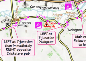
Leisure route: Avington and beyond
The Itchen Valley between Alresford and Winchester is a beautiful peaceful countryside route along quiet lanes. This ride uses the little-known cycle route through subways and paths over Junction 9 of the M3 – not as scary as it sounds, but there’s one bit where Highways England ask you to...
Read More
Mass Ride Route A: Kings Worthy
Start: Tesco Express, Springvale Road. Pause/joining point: Top of Bedfield Lane Printable map here...
Read More
Mass Ride Route B: Harestock & Weeke
Start: Tesco Express, Priors Dean Road. Pause/joining point: Grass area at corner of Stoney Lane and Stockbridge Road Printable map here...
Read More
Mass Ride Route C: Badger Farm & Stanmore
Meet: Meadow Way opposite Sainsbury’s emergency exit Pause/joining point: In front of shops, Cromwell Road Printable map here...
Read More
Mass Ride Route D: Highcliffe
Start: All Saints church car park Pause/joining point: The Screen cinema, Southgate Street Printable map here...
Read More